Monday, January 18, 2010

Bangkok Hospital

1. Bumrungrad International:
190 countries around the world who come here for treatment
Diagnostic & therapeutic

Ear,Nose, Throat Center
Heart Center
Horizon center: Bone Marrow and Stem Cell Transplantation
Orthopaedic Center
Plastic Surgery Center
Skin Center
Surgical Clinics
Women's Center

2.Bangkok Hospital:
Today, we are home to more than 20 specialized centers, covering almost every area of expertise, and supported with comprehensive emergency and ambulatory services.
Through our streamlined patient management system, we have been able to reduce waiting time to nearly zero.
BMC the preferred healthcare provider for more than 3.4 million patients from 160 countries.
Where it is: all over the world
What it is: a hospital catering to the needs of patients (it has many facilities)
Tourists visit this place to undergo medical treatment to improve their livelihood. Also, there are some people from other countires who do not go there for medical treatment. These people go there to see their medical facilities inorder to improve their own facilities.

Sources of information: http://www.bumrungrad.com/
Bangkok Hospital: strives to help you choose the best and most convenient options. From our hospital, a taxi is the easiest way to get around, dropping you at your destination or at the nearby Thong Lo or Ekkamai skytrain stations. The skytrain is fast and easy to use, and reaches most of Bangkok’s main attractions. It also works in partnership with Howa Taxi Service, offering the cleanest and most reliable taxi fleet in Bangkok. For sheer safety and convenience, we recommend you use this service. Fees are the same as those charged in regular meter taxis, but without the danger of miscommunication or car failure. Trips outside of Bangkok can be easily arranged via the taxi coordinator, who will quote a fixed, non-metered rate. The Howa Taxi booth is located to the right of the main hospital entrance.


                       http://www.restoredbeautygetaways.com/images/BangkokHospitalPattaya.jpg

What is this place?
It is a hospital located in Bangkok, Thailand. It was opened in 1972 by a team of doctors, pharmacists and 30 nurses. Bangkok Hospital Medical Center is a 520- bed tertiary care hospital with a 90-bed International Medical Center that focuses exclusively on international patients.


Where is this place?
It is located in Bangkok, Thailand.
The full address is 2 Soi Soonvijai 7, New Petchburi Road
Bangkapi , Huay Khwang Bangkok 10310.


Why do tourists visit this place?
It is one of the largest privately-owned hospitals in Southeast Asia and one of the most technologically sophisticated hospitals in the world today. It also provides healthcare for more than 3.4 million patients from some 160 countries. It offers a broad range of services including a retail pharmacy, a café and a 7/11 convenience store. Four hospitals and broad range of specialized clinics, BMC is equipped with all of the diagnostic and treatment facilities not generally available at local hospitals.Received many awards such as
·         Prime Ministers Export Award 2001
·         1st Place Hospital Asia Management Awards 2002
·         Superbrand Award Thailand 2003 & 2004
·         Selected by White House Medical Staff to Provide Medical Care to US President Bush and White House Staff during 2003 APEC Meeting in Bangkok, Thailand

Will medical tourism generate further income for the hospitals involved and for Thailand in general?
Yes. Thailand's assets as a center for medical care for foreigners are multiple. More foreigners came to Thailand to have medical treatment because the standard of treatment and technology is high. The prices are mostly lower than in other countries who provide similar quality and technology. The hospital environment in Thailand is clearly more hospitable. It is fair to say that all the hospitals mentioned above, also look good, are mostly new, and give a favorable impression as soon as you enter them. The tourism infrastructure is well developed.
Income from medical tourism to Thailand is projected to increase in the following years. It has to be recognized that 33 billion baht of income (about 850 million US dollar) is only a small proportion of the total income generated by tourism..
Does this all affect the medical care for the Thai population itself?
Yes. Most Thai patients can not afford to go to private hospitals. So where to they go to? Over the last few years the Thai Government has developed the so-called '30 baht scheme'. This is a universal healtcare programme whereby everybody get treatment at public hospitals for a standard fee per visit of only just 30 baht. Basically this amounts to free health care. The hospitals who participate in the scheme, get a lump sum per patient registered. We think at present it amounts to somewhat less than 2,000 baht per patient. It has to be recognized as a major achievement, since before that there hardly was any proper healtcare available for the poorer (that is the larger) part of the population.


http://www.thaiwebsites.com/medical-tourism-thailand.asp


²  Bumrungrad International:
-190 countries around the world who come here for treatment
- medical tourism
-'Bumrungrad” is Thai word - pronounced Bahm-roong-RAHT - means "care for the people"
 -Treatments available:
Ear,Nose, Throat Center
Heart Center
Horizon center:  Bone Marrow and Stem Cell Transplantation
Orthopaedic Center
Plastic Surgery Center   
Skin Center
Surgical Clinics     
Women's Center   

WHAT IS THIS PLACE:
This is a hospital which provides medical services.
WHERE IS THIS PLACE:
This place is all over the world/ This place is in Bangkok
WHY DO TOURISTS VIST THIS PLACE:
Mostly come for medical treatment, to receive the best and most efficient healthcare. A small number of people go to observe the way the hospital works, in order to improve other hospitals.
WHAT ARE THE SOURCES OF INFORMATION FOR THIS PLACE?: \ www.bumrungrad.com

2 OTHER QUESTIONS:
- will there be a problem with communication?
English is widely spoken around the hospital, and the Bumrungrad doctors, medical and customer service staff all speak English. If you do not speak in English, also employ 109 interpreters to help patients who speak other languages.
-       are there many tourists who come to undergo treatments at bumrungrad?
Yes! More than 1.3 million medical tourists a year; the majority of these travelers come from within Asia.


²  Bangkok Hospital:
- medical tourism
-It is home to more than 20 specialized centers, covering almost every area of expertise, and supported with comprehensive emergency and ambulatory services.
-Through they’re streamlined patient management system, they have been able to reduce waiting time to nearly zero.
-It is the preferred healthcare provider for more than 3.4 million patients from 160 countries. 
-strives to help you choose the best and most convenient options.from this hospital, a taxi is the easiest way to get around, dropping you at your destination or at the nearby Thong Lo or Ekkamai skytrain stations.
- The skytrain is fast and easy to use, and reaches most of Bangkok’s main attractions. It also works in partnership with Howa Taxi Service, offering the cleanest and most reliable taxi fleet in Bangkok. For sheer safety and convenience, we recommend you use this service. Fees are the same as those charged in regular meter taxis, but without the danger of miscommunication or car failure. Trips outside of Bangkok can be easily arranged via the taxi coordinator, who will quote a fixed, non-metered rate. The Howa Taxi booth is located to the right of the main hospital entrance.
WHAT IS THIS PLACE:
This is a hospital which provides medical services.
WHERE IS THIS PLACE:
This place is in Bangkok
WHY DO TOURISTS VIST THIS PLACE:
Mostly come for medical treatment, to receive the best and most efficient healthcare. A small number of people go to observe the way the hospital works, in order to improve other hospitals.
WHAT ARE THE SOURCES OF INFORMATION FOR THIS PLACE?: www.bangkokhospital.com

Done by Joy Chua 4R

Sunday, January 17, 2010

The Taj Mahal


The magnificent front view of the Taj Mahal reflected in River Yamada.
Source: http://khedo.files.wordpress.com/2007/12/taj-mahal.jpg

Where is this place?
Location: Agra, India


Another awe-inspiring view of the Taj Mahal in shades of grey.
Source: http://www.stonybrook.edu/globality/Articles/images/no5/Taj%20Mahal-big.jpg

What is this place?
The Taj Mahal( “Crown Palace”) is built in Agra between 1631 and 1648 by order of the Muslim Mughal emperor, Shah Jahan in memory of his favourite wife. In 1983, the Taj Mahal was listed in the UNESCO World Herritage Site and was cited as "the jewel of Muslim art in India and one of the universally admired masterpieces of the world's heritage."

Taj Mahal is a symbol of the Emperor ‘s “eternal love” towards his Queen, Mumtaz Mahal. It is a Mausoleum that houses the grave of queen Mumtaz Mahal at the lower chamber. When she was still alive, she wanted the Emperor to promise her to build the Taj, to marry again, to be kind to the children and to visit her tomb during her death anniversary. It took 20,000 workers and 22 years to complete this architecturally beautiful building.


Source: http://www.angelfire.com/in/myindia/tajmahal.html
The picturesque scenery of the Taj Mahal during sunset. As evident from the pictures, different aspects of the exquisite architecture come to light during the different times of the day.

Why do tourists visit this place?
The stunning architectural beauty of Taj Mahal attracts 2 to 4 million tourist annually. It is built of white marble and seems to glow in the light of full moon during dawn and sunset. The colours change at different hours of the day and during different seasons. The Taj is pinkish in the morning, milky white in the evening and golden when the moon shines. These changes, they say, depict the different moods of woman.

Many tourist visit to adore the beauty of Taj Mahal which is a part of a vast complex that comprise of a main gateway, an elaborate garden, a mosque, a guest house and several other palatial buildings.


A bird’s eye view of Taj Mahal
Source: http://www.smileosmile.com/wp-content/uploads/2009/02/tajmahal.jpg

How do tourist get there?
Most tourists visit in the cooler months of October, November and February. Polluting traffic is not allowed near the complex and tourists must either walk from parking lots or catch an electric bus.

What type of tourist attraction is this?
Cultural-historical.

Sources of information:
http://en.wikipedia.org/wiki/Taj_Mahal
http://www.islamicity.com/culture/Taj/default.htm
http://whc.unesco.org/en/list/252
http://www.angelfire.com/in/myindia/tajmahal.html

Done by: Soh Sheng Mei (25) 4R

Angkor Wat


Impressions of Angkor Wat ...

Location: Cambodia (Siem Reap)


Although there are hundreds or thousands of tourists who visit Angkor Wat everyday, a view like this can make you lose yourself, as you take in the re-defined version of picturesque...


(SourceURL http://www.lessons-from-history.com/Images/Great%2

0Projects/angkor_wat_cambodia.jpg)


A peripheral view of the Angkor Wat is captured in the picture above. Although it has been taken as an aerial shot, be sure not to under estimate the enormity o
f the complex!

(Source URL: http://thehindimusic.com/)

In the sunset, Angkor Wat takes on a new magical image...

Source URL: http://travelswithmycamera.files.wordpress.com/2009/04/angkor_wat.jpg

As evident from all the pictures, the beauty of

Angkor Wat changes with the light intensity, cloud cover and times of the day. Furthermore, the place can be captured from many angles. As Lonely Planet put it, “Ascend to the realm of the gods at the mother of all temples, Angkor Wat, a spectacular fusion of symbolism, symmetry and spirituality”.

What is this place?

Angkor Wat (or Angkor Vat) is a temple complex at Angkor, Cambodia, built for the king Suryavarman II in the early 12th century as his state temple and capital city. As the best-preserved temple at the site, it is the only one to have remained a significant religious centre since its foundation—first Hindu, dedicated to the god Vishnu, then Buddhist. The temple is the epitome of the high classical style of Khmer architecture. It has become a symbol of Cambodia, appearing on its national flag, and it is the country's prime attraction fo

r visitors

People may take from a few hours to a few days,

because conditions such as the weather, lighting conditions (i.e. the sunrise and sunset) all contribute to the relative appearances of the temple during the course of the day. Angkor provides wonderful photographic opportunities. The monuments and the surrounding jungle afford unlimited textural and lighting opportunities for composing a picture.

Why do tourists visit this place?

- Natural Heritage Site (preserved by UNESCO)

- Used to be in the 7 wonders of the world list

- Great opportunity for photographers and artists

- Accessibility (i.e. tourism is very much facilitated by the many hotels, and there is an airport at Siem Reap, Cambodia, where Angkor Wat is located)

- Stunning architectural beauty of the place


Sources of information:

- www.trivago.com/cambodia

- www.tourismcambodia.com

- www.lonelyplanet.com

- www.wikipedia.org

- www.angkorwhat.net


By Clarissa(4R) and Kala(4M):


Image Sites:


http://www.images-photography-pictures.net/Angkor-Wat-Cambodia-Siem-Reap-Hrtfried-Schmid.jpg
http://www.sacredsites.com/asia/cambodia/images/sunrise-angkor-wat-500.jpg


Questions about the Place:


What is this place?

Angkor Wat is a huge complex of ancient temples. It was built by the Khmer civilization between 802 and 1220 AD. It is one of mankind’s most astonishing and enduring architectural achievements.
Where is this Place?

It is located in Cambodia, in the city of Angkor.

Why do the tourists visit this place?

Many tourist want to see the grandeur and the magnificence of the place. The History of the place also attracts them. Angkor Wat is also one of the World’s Wonders, hence, people would be more interested about it.

Sources of information

http://www.sacredsites.com/asia/cambodia/angkor_wat.html
An informational site about Angkor Wat and other places in the world.

http://www.tripadvisor.com/ShowUserReviews-g297390-d317907-r53134668-Angkor_Wat-Siem_Reap.html
A tourist site filled with information for tourist destinations and reviews from tourists.

What type of tourist attraction is this?
Historical and cultural tourist attraction.


How much revenue does this place generate?


In 2008, the total ticket sales generated by Angkor Wat was approximately 30 million dollars.


demilitarized zone, north korea!


http://www.globalization101.org/uploads/Image/News%20Analyses/dmz.jpg


what is this place? Where is this place?
North Korea is located in Eastern Asia, northern half of the Korean Peninsula bordering the Korea Bay and the Sea of Japan, between China and South Korea. the Korean Demilitarized Zone (
Korean: 한반도 비무장지대) is a strip of land running across the Korean Peninsula that serves as a buffer zone between North and South Korea since 1953. The DMZ cuts the Korean Peninsula roughly in half, crossing the 38th parallel on an angle, with the west end of the DMZ lying south of the parallel and the east end lying north of it. It is 155 miles (248 km) long and approximately 2.5 miles (4 km) wide, and is the most heavily militarized border in
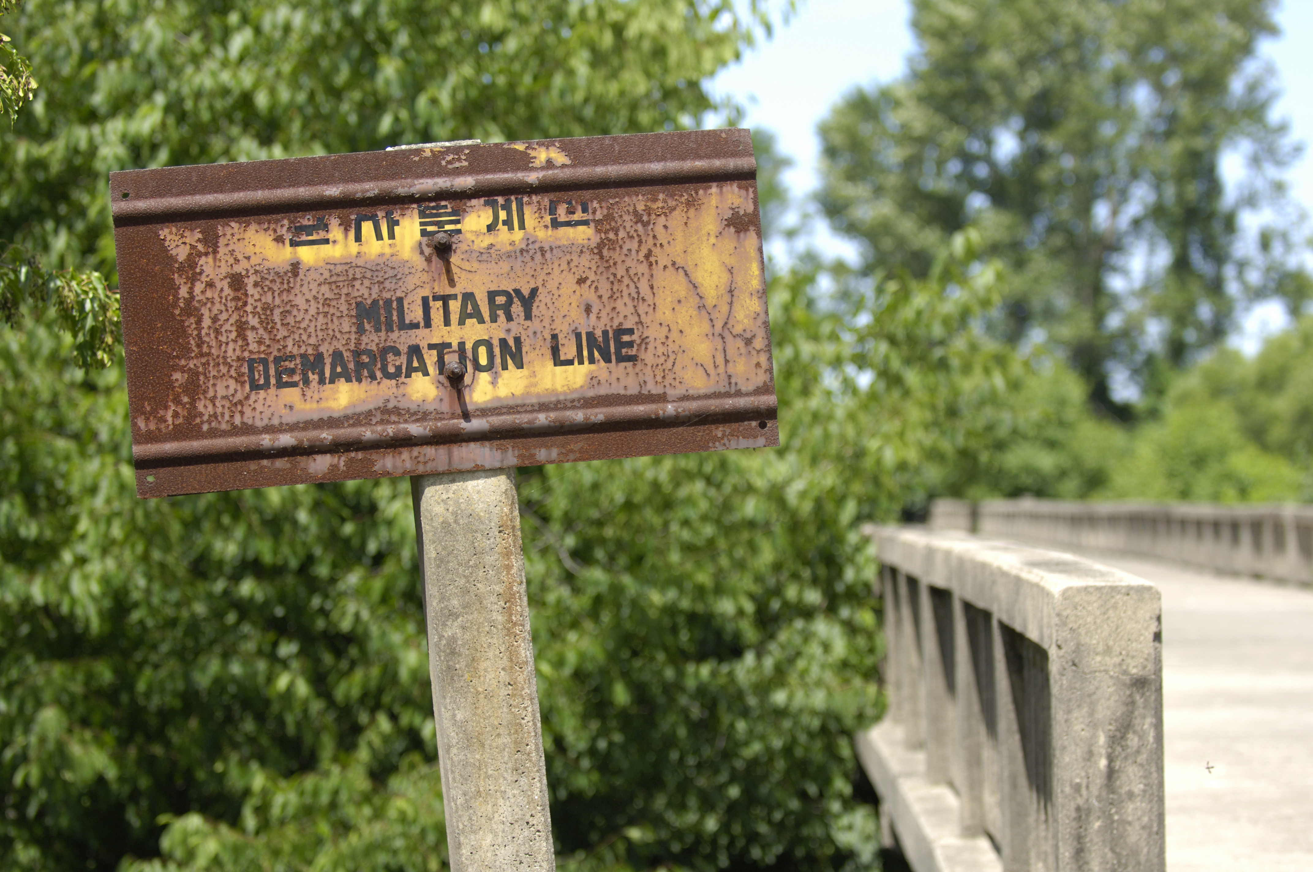
Military Demarcation Line marker on the South Korean side of the Bridge of No Returnthe world.


WHY DO TOURISTS VISIT DEMILITARIZED ZONE, NORTH KOREA?
There are many interesting things to see there. However travelling within the DMZ is possible only in official UN vehicles. The most interesting place is the three conference rooms that sit directly over the border. Visitors can also see the tunnels that North Korea troops dug under the DMZ. UN forces discovered these tunnels.


A South Korean checkpoint in the DMZ.

what are the sources of information for this place?
1. https://www.cia.gov/library/publications/the-world-factbook/geos/kn.html --> the world fact book has all the facts and information of every country existing in the world. Basically, the main categories are introduction, geography, people, government, economy, communication, transportations, military, and transitional issues.
2.
http://en.wikipedia.org/wiki/Korean_Demilitarized_Zone --> wikipedia is a website where one can find information about anything one needs. The website is updated often by various people around the world.
3. http://hubpages.com/hub/Visiting_the_Korean_DMZ
4. http://english.visitkorea.or.kr/enu/SI/SI_EN_3_6.jsp?cid=256850

Questions by us!
HOW DO TOURISTS GET THERE?
If tourists follow the tour group, they will take the tour bus. But usually if tourists want to see the inside of the demilitarized zone, they have to take only the UN vehicles in.
besides humans, what other living things can we find there?
In the past half century, the Korean DMZ has been a deadly place for humans, making habitation impossible. Only around the village of Panmunjeom and more recently the Dong Bukbu Line on Korea's east coast have there been regular incursions by people.
This natural isolation along the 155 miles (249 km) length of the DMZ has created an
involuntary park which is now recognised as one of the most well-preserved areas of temperate habitat in the world. Several endangered animal and plant species now exist among the heavily fortified fences, landmines and listening posts. These include the extremely rare Red-crowned Crane (a staple of Asian art), and the White-naped crane as well as, potentially, the extremely rare Korean Tiger , Amur leopard and Asiatic black bear. Ecologists have identified some 2,900 plant species, 70 types of mammals and 320 kinds of birds within the narrow buffer zone. Additional surveys are now being conducted throughout the region.
The DMZ, which is up to 2.5 miles (4.0 km) wide, owes its varied biodiversity to its geography which crosses mountains, prairies, swamps, lakes and tidal marshes. Environmentalists hope that by the time reunification occurs, the former DMZ will be conserved as a wildlife refuge, with a well-developed set of objective and management plans vetted and in place. In 2005 CNN founder and media mogul, Ted Turner, on a visit to North Korea, said that he would financially support any plans to turn the DMZ into a peace park and a UN-protected World Heritage Site.


this was posted by students of dynamique 4D-wen ying and katherine


By Clarissa and Kala(4M):


What is this place?

It is a border that stretches from the west to the east coast of the Korean peninsula. It is something of a misnomer, considering the huge number of military personnel ( over 2 million troops ) and materiel in position.

Where is this place?
It is where North and South Korea is divided. It is also known as “The 38th Parallel”.

Why do tourists visit this place?
It is one of the relics of the Cold War. It also has a large amount of biodiversity, as the DMZ has been restricted to the general public for over 50 years, causing it to be a wildlife preserve. It’s natural beauty and history attracts tourists.

Sources of information:

Tourist sites-


The Korean Demilitarized Zone (Korean: 한반도 비무장지대) is a strip of land running across the Korean Peninsula that serves as a buffer zone between North and South Korea. The DMZ cuts the Korean Peninsula roughly in half, crossing the 38th parallel on an angle, with the west end of the DMZ lying south of the parallel and the east end lying north of it. It is 155 miles (248 km) long and approximately 2.5 miles (4 km) wide, and is the most heavily militarized border in the world.


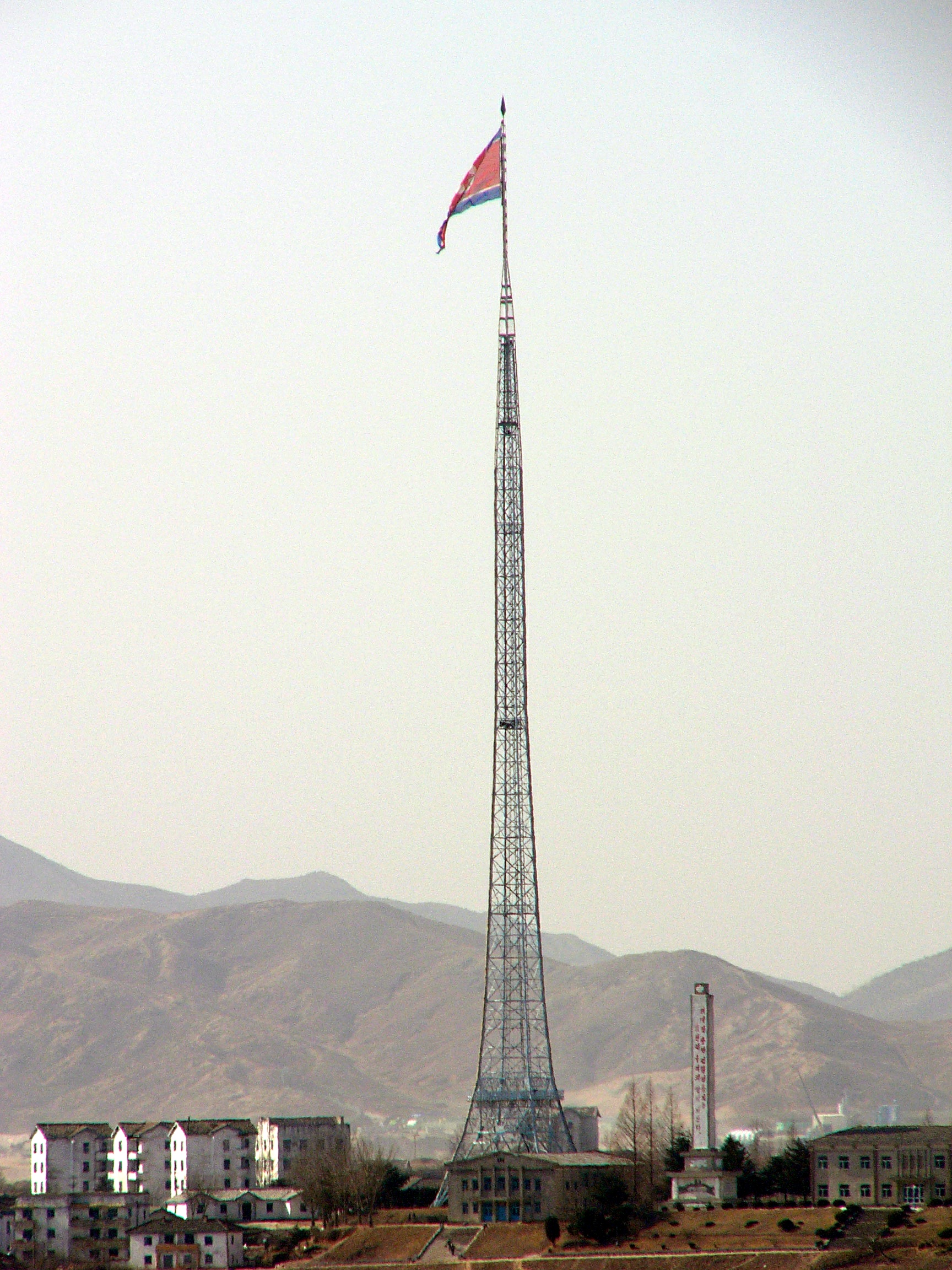
The tallest flagpole in the world in Kijong-dong.

Both North and
South Korea maintain peace villages in sight of each other's side of the DMZ. In the South,
Daeseong-dong Villagers are classed as Republic of Korea citizens, however they are exempt from paying tax and other civic requirements such as military service.
In the North,
Kijong-dong features a number of brightly painted, poured-concrete multi-story buildings and apartments with electric lighting. These features represented an unheard of level of luxury for rural Koreans, north or south, in the 1950s. The town was oriented so that the bright blue roofs and white sides of the buildings would be the most distinguishing features when viewed from the border. However scrutiny with modern telescopic lenses reveals that the buildings are mere concrete shells lacking window glass or even interior rooms, with the building lights turned on and off at set times and the empty sidewalks swept by a skeleton crew of caretakers in an effort to preserve the illusion of activity.
In 1998
South Korea built the Freedom Building in the JSA to host meetings between families separated by the Korean War. The DPRK enlarged its own building, Panmun Guk (
Panmum Hall), adding additional floors to make it taller.
During the 1980s, the South Korean government built a 98.4 metre (328 ft) tall flagpole in the
village of Daeseong-dong. The North Korean government responded by building a taller one — the tallest in the world at 160 metres (525 ft) in Kijong-dong.
 Korean wall


The alleged Korean Wall in the Demilitarized Zone
The Korean wall is a concrete barrier that was allegedly built along the length of the DMZ in South Korea between 1977 and 1979. Dutch journalist and filmmaker Peter Tetteroo shows footage of what he believes (at the prompting of his North Korean guides) to be the Korean Wall, dismissing South Korean denials as propaganda. North Korea contends:
In the area south of the Military Demarcation Line, which cuts across our country at its waist, there is a concrete wall which stretches more than 240 km (150 mi) from east to west, is five to eight meters (16 to 26 ft) high, 10 to 19 m (32 to 62 ft) thick at the bottom, and 3 to 7 m (10 to 23 ft) wide in the upper part. It is set with wire entanglements and dotted with gun embrasures, look-outs and varieties of military establishments [...] the South Korean rulers built this wall over a period of many years from 1977.

North Korea's longtime ambassador to China, claims that a "wall" divided Korea. He said the south side of the wall is packed with earth, which permits access to the top of the wall and makes it effectively invisible from the south side and also claimed that it served as a bridgehead for any northward invasion.
According to the United States, the wall does not exist, although there are anti-tank barriers along some sections of the DMZ.

Transportation

Main article: Panmunjeom


Military Demarcation Line marker on the South Korean side of the Bridge of No Return.

Panmunjeom is the site of the negotiations that ended the Korean War and is the main centre of human activity in the DMZ. The village is located on the main highway and near a railroad connecting the two Koreas.


Sarah Gan (6) and Stephanie Sim (23) 4R